High-Tech Drones, High-Impact Results

Elevating Your Success from Above.

You Will Love It.

Smart End-to-End Drone Solutions

Empowering organizations to implement drone based solution into their workflows..

01

DRONES

Our fleet of advanced drones is engineered to perform a wide range of tasks with unparalleled precision and reliability.

02

SERVICES

Our fleet of advanced drones is engineered to perform a wide range of tasks with unparalleled precision and reliability.

03

TRAINING

We offer comprehensive training programs designed to equip you with the skills and knowledge needed to operate drones effectively.

04

SENSORS

Our drones are equipped with a variety of high-performance sensors, designed to capture accurate and detailed data across different applications.

05

SOFTWARE

Harness the power of our drone-based software platforms to transform the data collected by drones into actionable intelligence.

06

ANALYTICS

Our advanced analytical tools are designed to maximize the value of the data collected by drones.

All Applocations

Explore Our Main Services

We provide expert inspection services for your organization’s mission critical assets using drone technology.

Agriculture Survey

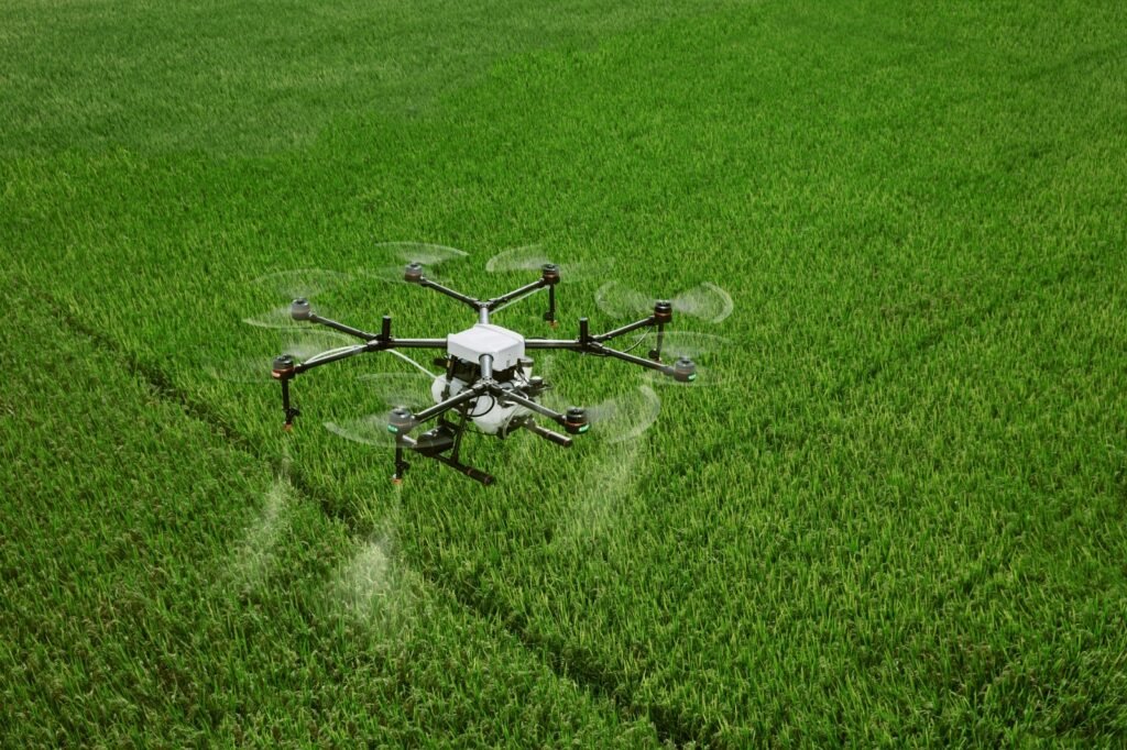
Hawks Eye's Drones For Agriculture Services Are Revolutionizing The Way Farmers And Agricultural Businesses Manage Their Crops And Land. These Services Provide High-resolution Aerial Imagery, Data Analysis, And Real-time Monitoring, Enabling Precise Decision-making To Enhance Crop Yield, Manage Resources Efficiently, And Detect Issues Like Pests Or Diseases Early.

Key Benefits Of Drones In Agriculture:
Precision Agriculture: Drones Offer Detailed Maps Of Crop Health, Soil Conditions, And Irrigation Levels, Allowing For Precise Application Of Water, Fertilizers, And Pesticides.

Time And Cost Efficiency: Drones Can Survey Large Areas Quickly, Reducing The Need For Manual Inspections And Saving Both Time And Labor Costs.

Early Detection Of Issues: With Multispectral Imaging, Drones Can Identify Crop Stress, Pest Infestations, And Disease Outbreaks Before They Become Visible To The Naked Eye, Allowing For Timely Interventions.

Improved Resource Management: By Analyzing Drone Data, Farmers Can Optimize The Use Of Water, Seeds, And Fertilizers, Reducing Waste And Increasing Efficiency.

Data-Driven Decisions: The Data Collected By Drones Is Processed Using Advanced Analytics, Providing Actionable Insights For Better Decision-making, From Planting To Harvesting.

Read More

Solar Industry Survey

Hawks Eye Plays A Pivotal Role Not Only In Optimizing Photovoltaic (PV) Systems But Also In Enhancing The Surrounding Infrastructure, Encompassing Utility Lines, Substations, And Fencing. Throughout Key Stages Like Pre-erection, Commissioning, And Operation And Maintenance, Our Surveys Serve Invaluable Purposes.
Drones Have Become An Indispensable Tool In The Solar Industry, Offering Numerous Benefits Across The Entire Lifecycle Of A Solar Project. From Site Assessment And Construction Monitoring To Ongoing Maintenance And Performance Evaluation, Drones Provide A Faster, Safer, And More Cost-effective Solution Compared To Traditional Methods. As Technology Continues To Advance, The Role Of Drones In The Solar Industry Is Expected To Grow, Contributing To The Efficiency, Sustainability, And Success Of Solar Energy Projects Worldwide.

The Primary Focus Is On Identifying Damaged Solar Panels Within Their Warranty Period, Facilitating Manufacturers To Promptly Restore Or Replace Them. This Proactive Approach Maximizes The Overall Output And Efficiency Of The Solar Farm While Effectively Reducing Maintenance Costs.

Read More

Industrial Inspection

Hawks Eye Is Revolutionizing The Inspection Industry. The Impact Of Human-free Aerial Automated Drone Inspections Is Creating Waves In Property Management Along With Various Sectors. Inspections Can Now Be Conducted Safely At A Distance Without The Use Of Expensive Scaffolding Or Cherry Pickers This Is A Priceless Victory. Large Areas Can Be Covered In Record Time As Complex Inspections Are Included.

Automated Drones Are Capable Of Fulfilling Various Applications. They Can Be Used In Oil And Gas Facilities For Security, Surveillance, Emergency Response, And Basic Infrastructure Inspections.

In Mining Operations, Drones Can Be Used In Stockpile Management, Tailings Dams, And Inspections. Drone Inspections Are Working In Almost Every Industry That Requires Visual Inspection As Part Of Maintenance Processes. Using Drones To Gather Visual Data On The Condition Of A Property Helps Inspectors Keep Themselves Out Of Harm’s Way In Hazardous Situations.

We Offers Many Benefits In Industrial Inspections, Enabling Rapid And Easy Scans Of Rooftops, Aerial Inspections With Time-saving, Revealing Faulty Infrared Signature Panels, Reaching Areas That Pose Health And Safety Risks To Humans, Reducing Response Time, And Minimizing Downtime.

Highlights

  • 3D Models For Informed Decision Making.
  • Fast & Accurate Data In Real Time To Manage Assets Proactively.
  • Thermal Imaging For Real-time Fault & Defect Analysis.
  • Critical Inventory Assets Monitoring& Inspection.
  • Safe Inspections In Difficult-to-reach Areas


Use Of Drone In Industrial Inspection

Drones Have Emerged As Powerful Tools For Industrial Inspection Across Various Sectors. Their Versatility And Capabilities Have Revolutionized The Way Inspections Are Conducted. Here Are Some Key Applications And Benefits Of Using Drones In Industrial Inspection:

  • Infrastructure Inspection
  • Oil And Gas Facilities
  • Power And Utility Lines
  • Construction Sites
  • Mining And Quarrying
  • Environmental Monitoring
  • Roof And Building Inspections
  • Telecom Towers
Read More

Lidar Survey

“In The World Of Advanced Surveying And Geospatial Data Collection, Hawks Eye Emerges As A Frontrunner In Leveraging The Transformative Capabilities Of Lidar Technology. With A Focus On Precision, Innovation, And Comprehensive Solutions, Hawks Eye Is Revolutionizing Industries That Depend On Precise Spatial Data.
Lidar, Which Uses Laser Pulses For Distance Measurement And Creating Detailed 3D Maps, Has Transformed Traditional Surveying Practices. Hawks Eye, Equipped With A Skilled Team And Cutting-edge Technology, Leads The Way In Lidar Surveying Across Various Sectors, Including Land Development And Disaster Response.
As A Pioneer In Lidar Surveying, They Ensure That Every Project Upholds The Highest Standards Of Quality And Accuracy. Their Commitment To Excellence Is Fostering Innovation And Progress, Paving The Way For A Brighter And More Accurate Future In Geospatial Data. With Hawks Eye, Precision Is Not Just A Promise—it’s A Guarantee, Establishing Them As A Symbol Of Excellence In The Rapidly Evolving Field Of Lidar Survey.”

Drones, Or Unmanned Aerial Vehicles (UAVs), Are Being Increasingly Integrated With Light Detection And Ranging (LiDAR) Technology For Diverse Surveying And Mapping Purposes. This Pairing Provides Numerous Benefits Compared To Conventional Surveying Techniques, Including Enhanced Efficiency, Precision, And Safety. Below Are Some Of The Primary Applications Of Drones In LiDAR Surveys:

  • Topographic Surveying
  • Forestry And Agricultural Analysis
  • Infrastructure Monitoring
  • Mining And Quarry Operations
  • Flood Risk Modeling And Control
  • Natural Disaster Evaluation
Read More

Bridges And Road Inspection

“Hawks Eye Offers Comprehensive Bridge And Road Inspection Services, With A Strong Emphasis On The Safety And Longevity Of Vital Transportation Infrastructure. Our Dedicated Team, Committed To Excellence, Utilizes Advanced Technology To Conduct Thorough Evaluations.
For Bridge Inspections, We Conduct Detailed Assessments That Encompass Both Visual And Structural Aspects, Focusing On Critical Components Like Decks, Superstructures, Substructures, And Foundations. We Identify Potential Issues And Provide Data-driven Solutions To Enhance The Longevity Of The Infrastructure.
In Road Inspections, We Employ State-of-the-art Equipment To Analyze Pavement Conditions, Detect Hazards, And Assess Overall Road Quality. Our Experienced Professionals Evaluate Factors Such As Surface Roughness, Ride Quality, Friction, And Skid Resistance, Offering Essential Insights For Maintenance And Rehabilitation Strategies.”
 

Key Benefits Of Use Of Drone For Bridges& Road Inspection

Drones, Often Referred To As Unmanned Aerial Vehicles (UAVs), Have Greatly Impacted Multiple Industries, Particularly In The Inspection Of Infrastructure Like Bridges And Roads. Their Application In These Inspections Offers Numerous Benefits, Improving Safety, Efficiency, And Precision. Here's How Drones Are Employed In This Field :

  • Collecting Aerial Data.
  • Enhancing Safety.
  • Analyzing Visual And Structural Aspects.
  • Efficient Use Of Cost And Time.
  • Monitoring Over Time.
  • Reaching Inaccessible Areas.
  • Creating 3D Models And Maps.
  • Integrating Data.
Read More

Power Line Monitoring


Services To Commence Soon.

Read More
All Solutions

Explore Our Main Services

We provide expert inspection services for your organization’s mission critical assets using drone technology.

Drone Data Process

Drone Data Process

  • Uploading And Storing Data
  • Processing Data
  • Analyzing And Interpreting Data
  • Reporting And Documenting Results
  • Ensuring Quality And Validating Data
  • Emerging Trends And Technologies
Read More

Pilots On Project

Hawks Eye Offers Professional Drone Pilot Services For Your Upcoming Project. Our Skilled And DGCA Certified Pilots Are Adept At Navigating And Capturing Precise Data, Delivering Essential Insights To Drive Your Project's Success.
Our Certified Pilots Bring Extensive Experience Across Various Project Settings. We Excel In Precise Mapping, Providing Detailed Layouts To Enhance Project Planning And Execution. Drones Accelerate The Survey Process, Cutting Down Time And Costs While Maintaining Data Accuracy. Our Drone Services Are Customized To Meet The Specific Needs Of Your Project, Offering The Flexibility Required. We Prioritize The Security Of Your Project Data, Ensuring Confidentiality And Adherence To Industry Standards. Receive Comprehensive Reports And Visual Data To Support Informed Decision-making.

Read More

3D Print


Services To Commence Soon.

Read More
Hit Counter